Tiedosto:AcrocephalusDumetorumIUCN.svg

Tämän PNG-esikatselun koko koskien SVG-tiedostoa: 800 × 566 kuvapistettä. Muut resoluutiot: 320 × 226 kuvapistettä | 640 × 453 kuvapistettä | 1 024 × 724 kuvapistettä | 1 280 × 905 kuvapistettä | 2 560 × 1 810 kuvapistettä | 1 052 × 744 kuvapistettä.
Alkuperäinen tiedosto (SVG-tiedosto; oletustarkkuus 1 052 × 744 kuvapistettä; tiedostokoko 8,67 MiB)
| Tämä tiedosto on tiedostotietokanta Wikimedia Commonsista. Tiedot kuvaussivulta näkyvät alla. |  |
Tiedoston kuvaussivu Commonsissa |
Yhteenveto
| Kuvaus |
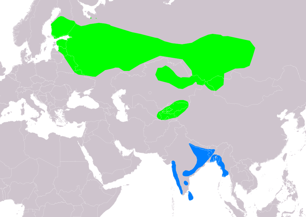
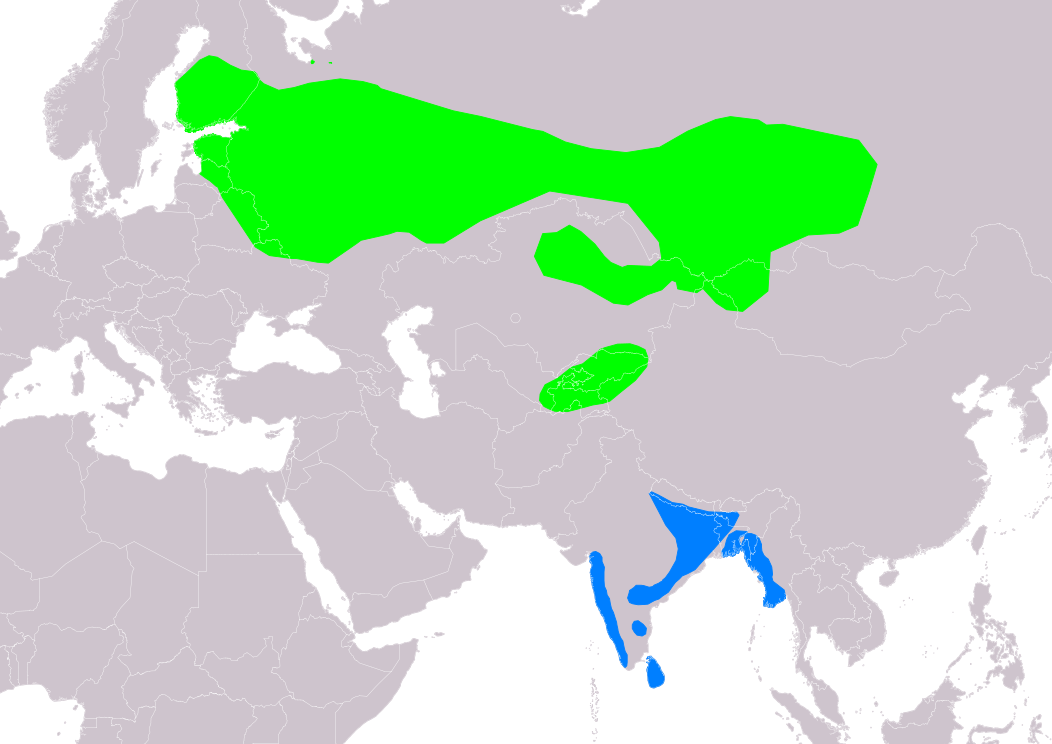
Slovenčina: Mapa rozšírenia druhu trsteniarik krovinový (Acrocephalus dumetorum) podľa IUCN verzia 2021.2 (Zostavil: BirdLife International and Handbook of the Birds of the World (2016) 2015.):
legenda: Hniezdiaci, výskyt v letnom období (#00FF00), Nehniezdiaci (#007FFF). English: Distribution map of Blyth's Reed-warbler (Acrocephalus dumetorum) according to IUCN version 2021.2 (Compiled by: BirdLife International and Handbook of the Birds of the World (2016) 2015.); key: Legend: Extant, breeding (#00FF00), Extant, non-breeding (#007FFF) |
| Päiväys | |
| Lähde | Made with Natural Earth. Free vector and raster map data @ naturalearthdata.com. Range map from BirdLife International. 2017. Acrocephalus dumetorum (amended version of 2016 assessment). The IUCN Red List of Threatened Species 2017: e.T22714736A111098258. https://dx.doi.org/10.2305/IUCN.UK.2017-1.RLTS.T22714736A111098258.en. as visual indicator of distribution. |
| Tekijä | SanoAK: Alexander Kürthy |
Lisenssi

Tämä tiedosto on lisensoitu Creative Commons Nimeä-JaaSamoin 3.0 Ei sovitettu -lisenssillä.
Nimeä: IUCN Red List of Threatened Species, species assessors and the authors of the spatial data.
- Voit:
- jakaa – kopioida, levittää ja esittää teosta
- remiksata – valmistaa muutettuja teoksia
- Seuraavilla ehdoilla:
- nimeäminen – Sinun on mainittava lähde asianmukaisesti, tarjottava linkki lisenssiin sekä merkittävä, mikäli olet tehnyt muutoksia. Voit tehdä yllä olevan millä tahansa kohtuullisella tavalla, mutta et siten, että annat ymmärtää lisenssinantajan suosittelevan sinua tai teoksen käyttöäsi.
- jaa samoin – Jos muutat tai perustat tähän työhön, voit jakaa tuloksena syntyvää työtä vain tällä tai tämän kaltaisella lisenssillä.
Tiedoston historia
Päiväystä napsauttamalla näet, millainen tiedosto oli kyseisellä hetkellä.
| Päiväys | Pienoiskuva | Koko | Käyttäjä | Kommentti | |
|---|---|---|---|---|---|
| nykyinen | 22. lokakuuta 2021 kello 22.33 | | 1 052 × 744 (8,67 MiB) | SanoAK | Uploaded a work by SanoAK: Alexander Kürthy from Made with Natural Earth. Free vector and raster map data @ naturalearthdata.com. Range map from BirdLife International. 2017. Acrocephalus dumetorum (amended version of 2016 assessment). The IUCN Red List of Threatened Species 2017: e.T22714736A111098258. https://dx.doi.org/10.2305/IUCN.UK.2017-1.RLTS.T22714736A111098258.en. as visual indicator of distribution. with UploadWizard |
Tiedoston käyttö
Seuraava sivu käyttää tätä tiedostoa:
Tiedoston järjestelmänlaajuinen käyttö
Seuraavat muut wikit käyttävät tätä tiedostoa:
- Käyttö sivustolla ar.wiki.x.io
- Käyttö sivustolla arz.wiki.x.io
- Käyttö sivustolla ast.wiki.x.io
- Käyttö sivustolla bg.wiki.x.io
- Käyttö sivustolla ca.wiki.x.io
- Käyttö sivustolla cs.wiki.x.io
- Käyttö sivustolla cy.wiki.x.io
- Käyttö sivustolla de.wiki.x.io
- Käyttö sivustolla en.wiki.x.io
- Käyttö sivustolla eo.wiki.x.io
- Käyttö sivustolla es.wiki.x.io
- Käyttö sivustolla eu.wiki.x.io
- Käyttö sivustolla ga.wiki.x.io
- Käyttö sivustolla he.wiki.x.io
- Käyttö sivustolla nl.wiki.x.io
- Käyttö sivustolla pl.wiki.x.io
- Käyttö sivustolla ru.wiki.x.io
- Käyttö sivustolla sk.wiki.x.io
- Käyttö sivustolla sv.wiki.x.io
- Käyttö sivustolla www.wikidata.org
- Käyttö sivustolla zh.wiki.x.io