Tiedosto:Earthquake wave paths.png

Earthquake_wave_paths.png (300 × 250 kuvapistettä, 13 KiB, MIME-tyyppi: image/png)
| Tämä tiedosto on tiedostotietokanta Wikimedia Commonsista. Tiedot kuvaussivulta näkyvät alla. |  |
Tiedoston kuvaussivu Commonsissa |

|
Tästä tiedostosta on saatavilla myös SVG-versio eli vektorigrafiikkatiedosto. SVG-versiota tulisi suosia, mikäli se on laadultaan tätä rasterikuvaa parempi.
File:Earthquake wave paths.png → File:Earthquake wave paths.svg
|
 |
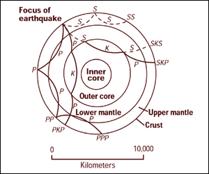
Cross section of the whole Earth, showing the complexity of paths of earthquake waves. The paths curve because the different rock types found at different depths change the speed at which the waves travel. Solid lines marked P are compressional waves; dashed lines marked S are shear waves. S waves do not travel through the core but may be converted to compressional waves (marked K) on entering the core (PKP, SKS). Waves may be reflected at the surface (PP, PPP, SS).
Seismographs detect the various types of waves. Analysis of such records reveals structures within the Earth.
Source: http://pubs.usgs.gov/gip/interior/fig2.gif ; original upload in english wikipedia, 15 April 2005 by SEWilco
Tämän teoksen on valmistanut Yhdysvaltain geologiaviraston (United States Geological Survey, USGS) työntekijä osana kyseisen työntekijän virkatointa. Yhdysvaltain liittovaltion viranomaisten työntekijöiden tekemät teokset eivät saa tekijänoikeuden suojaa Yhdysvaltain tekijänoikeuslain 105 § mukaisesti.
|
Alkuperäinen tallennusloki
| Päiväys | Koko | Käyttäjä | Kommentti |
|---|---|---|---|
| 4. syyskuuta 2005, 12:53:16 | 300 × 250 (13208 bytes) | Saperaud (keskustelu · muokkaukset) | Cross section of the whole [[Earth]], showing the complexity of paths of [[earthquake]] waves. The paths curve because the different rock types found at different depths change the speed at which the waves travel. Solid lines marked P are compressional wa |
Tiedoston historia
Päiväystä napsauttamalla näet, millainen tiedosto oli kyseisellä hetkellä.
| Päiväys | Pienoiskuva | Koko | Käyttäjä | Kommentti | |
|---|---|---|---|---|---|
| nykyinen | 6. tammikuuta 2015 kello 18.54 | | 300 × 250 (13 KiB) | GifTagger | Bot: Converting file to superior PNG file. (Source: Earthquake_wave_paths.gif). This GIF was problematic due to non-greyscale color table. |
Tiedoston käyttö
Seuraavat 2 sivua käyttävät tätä tiedostoa:
Tiedoston järjestelmänlaajuinen käyttö
Seuraavat muut wikit käyttävät tätä tiedostoa:
- Käyttö sivustolla ary.wiki.x.io
- Käyttö sivustolla cs.wiki.x.io
- Käyttö sivustolla de.wiki.x.io
- Käyttö sivustolla en.wiki.x.io
- Käyttö sivustolla es.wiki.x.io
- Käyttö sivustolla fr.wiki.x.io
- Käyttö sivustolla it.wiki.x.io
- Käyttö sivustolla nds.wiki.x.io
- Käyttö sivustolla sk.wiki.x.io
- Käyttö sivustolla tr.wiki.x.io
- Käyttö sivustolla vi.wiki.x.io
- Käyttö sivustolla zh-yue.wiki.x.io
- Käyttö sivustolla zh.wiki.x.io