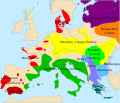
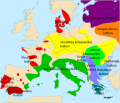
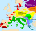
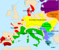
Tiedosto:European Middle Neolithic.gif

Alkuperäinen tiedosto (1 307 × 648 kuvapistettä, 101 KiB, MIME-tyyppi: image/gif)

Yhteenveto

Tästä tiedostosta on saatavilla myös SVG-versio eli vektorigrafiikkatiedosto. SVG-versiota tulisi suosia, mikäli se on laadultaan tätä rasterikuvaa parempi.

File:European Middle Neolithic.gif → File:European-middle-neolithic-en.svg


Muilla kielillä
Alemannisch  العربية  беларуская (тарашкевіца)  български  বাংলা  català  нохчийн  čeština  dansk  Deutsch  Ελληνικά  English  British English  Esperanto  español  eesti  euskara  فارسی  suomi  français  Frysk  galego  Alemannisch  עברית  hrvatski  magyar  հայերեն  Bahasa Indonesia  Ido  italiano  日本語  ქართული  한국어  lietuvių  македонски  മലയാളം  Bahasa Melayu  norsk bokmål  Plattdüütsch  Nederlands  norsk nynorsk  norsk  occitan  polski  prūsiskan  português  português do Brasil  română  русский  sicilianu  Scots  slovenčina  slovenščina  српски / srpski  svenska  தமிழ்  ไทย  Türkçe  татарча / tatarça  українська  vèneto  Tiếng Việt  中文  中文(中国大陆)  中文(简体)  中文(繁體)  中文(马来西亚)  中文(新加坡)  中文(臺灣)  中文(臺灣)  +/−
SVG-tiedosto

.

Kuvaus
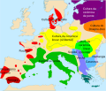
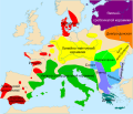
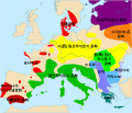
English: Map of the second half European Middle Neolithic at the apogee of Danubian and Mediterranean expansion.
(The modification of the original map - Combed pottery, earlier notated as Pitted Ware, see history without respecting the color code of the legend is something that I am not fully satisfied with).
Päiväys 5. huhtikuuta 2005 (alkuperäinen tallennuspäivä)
Lähde Siirretty projektista en.wikipedia Commonsiin.
Tekijä

Sugaar projektissa Wikipedia kielellä englanti

Later versions were uploaded by Clarifer at en.wikipedia.
Muut versiot

[muokkaa]

Maps of the history of Europe
BCE
aC

Weichselian ice age (c. 113,000–9700) · Neolithic expansion (c. 7000–4500) · Middle Neolithic (c. 4500–4000) · Late Neolithic (c. 4000–3000) · Copper Age – Corded Ware culture (c. 2900–2350) · Copper Age – Bellbeaker culture (c. 2800–1800) · Early Bronze Age – Unetice culture (c. 2300–1600) · Late Bronze Age – Urnfield culture (c. 1300—750) · Migrations (c. 1000–100) · Hallstatt & La Tène cultures (c. 800–100) · Roman Republic (510–40) · 220 · 218 · 200 · 201–100 · 58 · 49 · 39 · 30 BCE–6 CE


CE
dC

14 · 14–37 · 60 · 60 · 69 · 80 · Migrations 100–500 · 117 · 117 · 125 · Migrations 150–774 · Economy 180 · 271 · 293–305 · 337 · 395 · c. 395 · 400 · 400 · 450 · 457–61 · 476 · 480 · Franks 481–814 · Early Slavs 500–700 · 500 · 526 · 526–600 · Christianisation to 600 · c. 550 · 650 · Pontic Steppe 650 · 665 · 800 · Vikings 800–1050 · 814 · 843–70 · 850 · 900 · 912 · 998 · 1000 · 1000 · 1054 · 1092 · First Crusade 1095–99 · 1097 · 1135 · 1142 · 1147–49 · 1190 · 1190 · 1250 · c. 1250 · 1301-1400 · 1301-1400 · 1328 · 1345 · Black Plague 1347–51 · 1360 · 1400 · Trade routes c. 1400 · 1430 · 1470 · 1490 · 1492 · 1500 · 1519 · 1550 · 1560 · Religion 1560 · Religion 1600 · Religion 1618 · 1618–48 · 1648 · 1683 · 1700 · 1701 · 1708 · 1714 · 1721 · 1725–30 · 1739–1740 · 1740 · 1748–66 · 1783–1792 · 1787 · 1787 · 1789 · 1799 · 1812 · 1812 · 1812 · 1812 · 1813 · 1815 · 1815 · 1815 · 1818 · Ottoman Empire 1830–1923 · 1848–49 · 1861 · 1867 · 1871 · 1878 · 1890 · 1905 · 1911 · 1914 · 1914 · 1919 · 1919–29 · 1923 · 1929 · 1930 · 1940 · 1941–42 · 1942–45 · Cold War 1947–91 · 1950 · 1993–2006 · 2006 to date

(this template: · view · discuss )

Lisenssi

Public domain Tämän teoksen tekijä, Sugaar projektissa Wikipedia kielellä englanti, on julkaissut sen public domainiin. Tämä on voimassa maailmanlaajuisesti.
Joissain maissa laki ei mahdollista tätä. Mikäli näin on:
Sugaar myöntää kaikille oikeuden käyttää tätä teosta mihin tahansa tarkoitukseen ilman minkäänlaisia ehtoja, ellei laki vaadi ehtojen asettamista.

Alkuperäinen tallennusloki

Alkuperäinen kuvaussivu oli täällä. Käyttäjätunnukset alla viittaavat kohteeseen en.wikipedia.
  • 2005-08-28 13:11 Clarifer 1320×663×8 (106148 bytes) Added the approximate area of the Comb Ceramic culture. Source: National Board of Antiquities, Finland. www.nba.fi
  • 2005-04-05 20:12 Sugaar 1320×663×8 (103228 bytes) Map of the second half European Middle Neolithic at the apogee of Danubian and Mediterranean expansion (c. 4500-4000 BCE). Made by [[Sugaar]]. Free use authorized by the author.

Kuvatekstit

Lisää yhden rivin pituinen kuvaus tästä tiedostosta

Kohteet, joita tässä tiedostossa esitetään

esittää

5. huhtikuu 2005

Tiedoston historia

Päiväystä napsauttamalla näet, millainen tiedosto oli kyseisellä hetkellä.

PäiväysPienoiskuvaKokoKäyttäjäKommentti
nykyinen18. huhtikuuta 2014 kello 08.43Pienoiskuva 18. huhtikuuta 2014 kello 08.43 tallennetusta versiosta1 307 × 648 (101 KiB)Spiridon Ion CepleanuNeolithic shorelines and banks, little details
22. maaliskuuta 2010 kello 02.39Pienoiskuva 22. maaliskuuta 2010 kello 02.39 tallennetusta versiosta1 307 × 648 (101 KiB)Ras67cropped
14. helmikuuta 2007 kello 02.50Pienoiskuva 14. helmikuuta 2007 kello 02.50 tallennetusta versiosta1 320 × 663 (104 KiB)32XAuf eine alte Version zurückgesetzt
14. helmikuuta 2007 kello 02.49Pienoiskuva 14. helmikuuta 2007 kello 02.49 tallennetusta versiosta1 320 × 663 (101 KiB)32XOriginal version by Sugaar.
31. joulukuuta 2005 kello 13.14Pienoiskuva 31. joulukuuta 2005 kello 13.14 tallennetusta versiosta1 320 × 663 (104 KiB)GlennOriginally uploaded to en-wiki: Quote: "Map of the second half European Middle Neolithic at the apogee of Danubian and Mediterranean expansion (c. 4500-4000 BCE)." Upload text: "20:12, 5 April 2005 . . Sugaar . . 1320x663 (103228 bytes) (Map of the secon

Tiedoston järjestelmänlaajuinen käyttö

Seuraavat muut wikit käyttävät tätä tiedostoa:

Näytä lisää tämän tiedoston järjestelmänlaajuista käyttöä.