Tiedosto:Francia 814.svg

Tämän PNG-esikatselun koko koskien SVG-tiedostoa: 500 × 380 kuvapistettä. Muut resoluutiot: 316 × 240 kuvapistettä | 632 × 480 kuvapistettä | 1 011 × 768 kuvapistettä | 1 280 × 973 kuvapistettä | 2 560 × 1 946 kuvapistettä.
Alkuperäinen tiedosto (SVG-tiedosto; oletustarkkuus 500 × 380 kuvapistettä; tiedostokoko 771 KiB)
| Tämä tiedosto on tiedostotietokanta Wikimedia Commonsista. Tiedot kuvaussivulta näkyvät alla. |  |
Tiedoston kuvaussivu Commonsissa |
Yhteenveto
Tämä vektorigrafiikkatiedosto luotiin käyttäen apuna ohjelmaa Inkscape .


.svg)
.svg)
.svg)
.svg)
.svg)


.svg)
.svg)
.svg)


.png)
.png)


.svg)


.svg)

.svg)


.svg)
.svg)
.svg)
.svg)


.svg)
.png)


.svg)


.svg)
.svg)


.svg)


.svg)


.png)
.svg)
.svg)
.svg)
.svg)
.svg)
.svg)
.svg)
_cropped.svg)
.svg)
.svg)
.svg)
.svg)
.svg)
.svg)
.svg)
.svg)
.svg)
.svg)
.svg)
.svg)
.svg)
.svg)
.svg)
.svg)
.svg)
.svg)
.svg)
.svg)
.svg)
.svg)
.svg)
.svg)
.svg)
.svg)
.svg)
.svg)
.svg)
.svg)
.svg)
.svg)
.svg)
.svg)
.svg)
.svg)
.svg)
.svg)
.svg)
.svg)
.svg)
.svg)
.svg)
.svg)
.svg)
Lisenssi
Tämä tiedosto on lisensoitu Creative Commons Nimeä-JaaSamoin 4.0 Kansainvälinen -lisenssillä.
- Voit:
- jakaa – kopioida, levittää ja esittää teosta
- remiksata – valmistaa muutettuja teoksia
- Seuraavilla ehdoilla:
- nimeäminen – Sinun on mainittava lähde asianmukaisesti, tarjottava linkki lisenssiin sekä merkittävä, mikäli olet tehnyt muutoksia. Voit tehdä yllä olevan millä tahansa kohtuullisella tavalla, mutta et siten, että annat ymmärtää lisenssinantajan suosittelevan sinua tai teoksen käyttöäsi.
- jaa samoin – Jos muutat tai perustat tähän työhön, voit jakaa tuloksena syntyvää työtä vain tällä tai tämän kaltaisella lisenssillä.
Tiedoston historia
Päiväystä napsauttamalla näet, millainen tiedosto oli kyseisellä hetkellä.
| Päiväys | Pienoiskuva | Koko | Käyttäjä | Kommentti | |
|---|---|---|---|---|---|
| nykyinen | 24. toukokuuta 2016 kello 21.04 | | 500 × 380 (771 KiB) | Alphathon | Corrected Bulgarian Empire |
| 24. toukokuuta 2016 kello 06.49 |  | 500 × 380 (732 KiB) | Alphathon | Split up Khazars and Magyars | |
| 24. toukokuuta 2016 kello 06.17 |  | 500 × 380 (723 KiB) | Alphathon | Split up Bulgarians and Slavs and made some minor corrections to path/group names | |
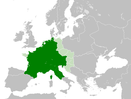
| 24. toukokuuta 2016 kello 05.31 |  | 500 × 380 (747 KiB) | Alphathon | == {{int:filedesc}} == {{Inkscape}} {{Information |Description={{en|A map of the en:Carolingian Empire (a.k.a. Francia, the Frankish Empire) within Europe circa 810 CE.}} |Source= {{Derived from|Blank_map_of_Europe.svg|display=50}} '''Data... |
Tiedoston käyttö
Seuraava sivu käyttää tätä tiedostoa:
Tiedoston järjestelmänlaajuinen käyttö
Seuraavat muut wikit käyttävät tätä tiedostoa:
- Käyttö sivustolla an.wiki.x.io
- Käyttö sivustolla ar.wiki.x.io
- Käyttö sivustolla arz.wiki.x.io
- Käyttö sivustolla ast.wiki.x.io
- Käyttö sivustolla bg.wiki.x.io
- Käyttö sivustolla cs.wiki.x.io
- Käyttö sivustolla el.wiki.x.io
- Käyttö sivustolla en.wiki.x.io
- Käyttö sivustolla eo.wiki.x.io
- Käyttö sivustolla es.wiki.x.io
- Käyttö sivustolla fa.wiki.x.io
- Käyttö sivustolla fr.wiki.x.io
- Käyttö sivustolla fr.wikiversity.org
- Käyttö sivustolla gl.wiki.x.io
- Käyttö sivustolla gl.wiktionary.org
- Käyttö sivustolla he.wiki.x.io
- Käyttö sivustolla hi.wiki.x.io
- Käyttö sivustolla hr.wiki.x.io
- Käyttö sivustolla hy.wiki.x.io
Näytä lisää tämän tiedoston järjestelmänlaajuista käyttöä.
.png)