Tiedosto:German Confederation (1815).svg

Tämän PNG-esikatselun koko koskien SVG-tiedostoa: 450 × 456 kuvapistettä. Muut resoluutiot: 237 × 240 kuvapistettä | 474 × 480 kuvapistettä | 758 × 768 kuvapistettä | 1 011 × 1 024 kuvapistettä | 2 021 × 2 048 kuvapistettä.
Alkuperäinen tiedosto (SVG-tiedosto; oletustarkkuus 450 × 456 kuvapistettä; tiedostokoko 801 KiB)
| Tämä tiedosto on tiedostotietokanta Wikimedia Commonsista. Tiedot kuvaussivulta näkyvät alla. | .svg?uselang=fi) |
Tiedoston kuvaussivu Commonsissa |


.svg)
.svg)
.svg)
.svg)
.svg)


.svg)
.svg)
.svg)


.png)
.png)


.svg)


.svg)

.svg)


.svg)
.svg)
.svg)
.svg)


.svg)
.png)


.svg)


.svg)
.svg)


.svg)


.svg)


.svg)
.svg)
.svg)
.svg)
.svg)
.svg)
.svg)
_cropped.svg)
.svg)
.svg)
.svg)
.svg)
.svg)
.svg)
.svg)
.svg)
.svg)
.svg)
.svg)
.svg)
.svg)
.svg)
.svg)
.svg)
.svg)
.svg)
.svg)
.svg)
.svg)
.svg)
.svg)
.svg)
.svg)
.svg)
.svg)
.svg)
.svg)
.svg)
.svg)
.svg)
.svg)
.svg)
.svg)
.svg)
.svg)
.svg)
.svg)
.svg)
.svg)
.svg)
.svg)
.svg)
Tiedoston historia
Päiväystä napsauttamalla näet, millainen tiedosto oli kyseisellä hetkellä.
| Päiväys | Pienoiskuva | Koko | Käyttäjä | Kommentti | |
|---|---|---|---|---|---|
| nykyinen | 8. maaliskuuta 2023 kello 06.16 | | 450 × 456 (801 KiB) | Varnalut | Reverted to version as of 01:14, 12 August 2013 (UTC) |
| 8. maaliskuuta 2023 kello 00.25 |  | 450 × 456 (683 KiB) | Varnalut | Reverted to version as of 12:54, 11 August 2013 (UTC) | |
| 12. elokuuta 2013 kello 03.14 |  | 450 × 456 (801 KiB) | TRAJAN 117 | Update | |
| 11. elokuuta 2013 kello 22.55 |  | 450 × 456 (795 KiB) | TRAJAN 117 | Updated | |
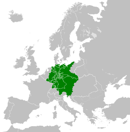
| 11. elokuuta 2013 kello 14.54 |  | 450 × 456 (683 KiB) | TRAJAN 117 | {{Information |Description ={{en|1=The German Confederation in 1815.}} |Source ={{own}} {{AttribSVG|Blank map of Europe 1815.svg|Alphathon}} |Author =TRAJAN 117 |Date =2013-08-11 |Permission ={{Self|... |
Tiedoston käyttö
Seuraava sivu käyttää tätä tiedostoa:
Tiedoston järjestelmänlaajuinen käyttö
Seuraavat muut wikit käyttävät tätä tiedostoa:
- Käyttö sivustolla ang.wiki.x.io
- Käyttö sivustolla arz.wiki.x.io
- Käyttö sivustolla ast.wiki.x.io
- Käyttö sivustolla az.wiki.x.io
- Käyttö sivustolla be.wiki.x.io
- Käyttö sivustolla en.wiki.x.io
- Käyttö sivustolla en.wiktionary.org
- Käyttö sivustolla ff.wiki.x.io
- Käyttö sivustolla gl.wiki.x.io
- Käyttö sivustolla he.wiki.x.io
- Käyttö sivustolla he.wiktionary.org
- Käyttö sivustolla kn.wiki.x.io
- Käyttö sivustolla ko.wiki.x.io
- Käyttö sivustolla ku.wiki.x.io
- Käyttö sivustolla la.wiki.x.io
- Käyttö sivustolla lld.wiki.x.io
- Käyttö sivustolla lt.wiki.x.io
- Käyttö sivustolla lv.wiki.x.io
- Käyttö sivustolla mk.wiki.x.io
- Käyttö sivustolla mn.wiki.x.io
- Käyttö sivustolla pl.wiki.x.io
- Käyttö sivustolla pt.wiki.x.io
- Käyttö sivustolla ru.wiki.x.io
- Käyttö sivustolla sco.wiki.x.io
- Käyttö sivustolla sq.wiki.x.io
- Käyttö sivustolla th.wiki.x.io
- Käyttö sivustolla uk.wiki.x.io
- Käyttö sivustolla uz.wiki.x.io
- Käyttö sivustolla www.wikidata.org
- Käyttö sivustolla xmf.wiki.x.io
.svg)