Tiedosto:Pyrenees topographic map-fr.svg

Alkuperäinen tiedosto (SVG-tiedosto; oletustarkkuus 3 200 × 1 900 kuvapistettä; tiedostokoko 6,38 MiB)
| Tämä tiedosto on tiedostotietokanta Wikimedia Commonsista. Tiedot kuvaussivulta näkyvät alla. |  |
Tiedoston kuvaussivu Commonsissa |
![]()
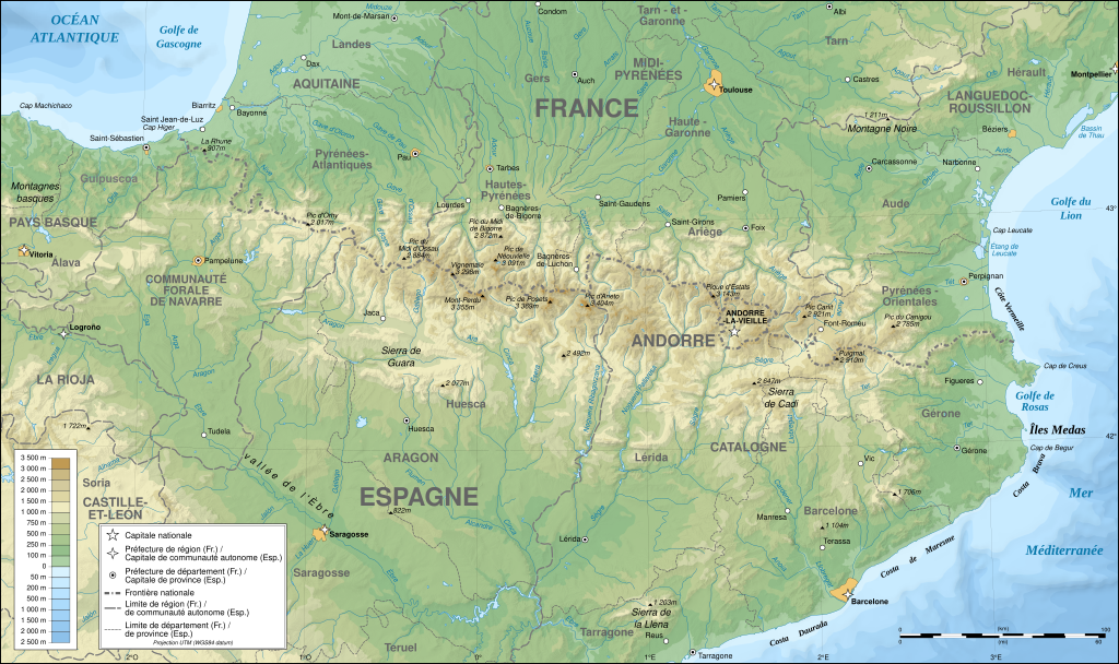
Detailed map of large dimension. For a better viewing, click on the link of the image above.
Carte détaillée de grande dimension. Pour une visualisation optimale, cliquer sur le lien de l'image ci-dessus.
Yhteenveto
| Kuvailu |
English: Topographic map in French of the Pyrenees mountains.
Note: The shaded relief is a raster image embedded in the SVG file. Français : Carte topographique des Pyrénées en francais.
Note : Le relief ombré est une image bitmap embarquée dans le fichier SVG. Português: Mapa topográfico (em Francês) dos Pirenéus.
Español: Mapa topográfico (en francés) de los Pirineos.
UTM projection; WGS84 datum; shaded relief (composite image of N-W, W and N lightning positions);
|
||
| SVG kehittely | |||
| Päiväys | May 2007 (modified September 2008) | ||
| Lähde |
Own work;
|
||
| Tekijä | |||
| Käyttöoikeus (Tämän tiedoston uudelleenkäyttö) |
|
||
| Georeferointi | If inappropriate please set warp_status = skip to hide. | ||
| Muut versiot |
[]
|


Arviointi
|

Tämä kuva valittiin päivän kuvaksi 1. elokuuta 2007. Sen kuvaus oli seuraavanlainen: Suomi: Topografinen kartta Ranskasta, Pyreneiden vuorilta. Päivän kuva:
Čeština: Francouzská mapa pohoří Pyreneje Dansk: Topografisk kort over Pyrenæerne på fransk. English: Topographic map in French of the Pyrenees mountains. Français : Carte topographique des Pyrénées en français. Magyar: A Pireneusok térképe Nederlands: Franse Topografische kaart van de Pyreneeën Português: Um mapa topográfico em francês, da região dos Pireneus. Română: Hartă topografică a munților Pirinei, Franța. Suomi: Topografinen kartta Ranskasta, Pyreneiden vuorilta. Svenska: Topografisk karta över Pyrenéerna på franska. Русский: Топографическая карта Пиренеев. Українська: Топографічна карта Піренеїв 中文: 法语注释的比利牛斯山地形图 中文(繁體): 庇里牛斯山的法語地形圖 עברית : מפה טופוגרפית בצרפתית של הרי הפירינאים |
Lisenssi

|
Voit kopioida, levittää ja/tai muuttaa tätä asiakirjaa GNU Free Documentation License -lisenssin version 1.2 tai minkä tahansa Free Software Foundationin julkaiseman myöhemmän version ehtojen alaisena; ei koske muuttumattomia kohtia, etukannen tekstejä eikä takakannen tekstejä. Kopio tästä lisenssistä on saatavilla osiossa GNU Free Documentation License. |
| Tämä tiedosto on lisensoitu Creative Commons Nimeä-JaaSamoin 3.0 Ei sovitettu -lisenssillä. | ||
| ||
| Lisensointimerkintä lisätiin tähän tiedostoon osana GFDL-lisensointipäivitystä. |
- Voit:
- jakaa – kopioida, levittää ja esittää teosta
- remiksata – valmistaa muutettuja teoksia
- Seuraavilla ehdoilla:
- nimeäminen – Sinun on mainittava lähde asianmukaisesti, tarjottava linkki lisenssiin sekä merkittävä, mikäli olet tehnyt muutoksia. Voit tehdä yllä olevan millä tahansa kohtuullisella tavalla, mutta et siten, että annat ymmärtää lisenssinantajan suosittelevan sinua tai teoksen käyttöäsi.
- jaa samoin – Jos muutat tai perustat tähän työhön, voit jakaa tuloksena syntyvää työtä vain tällä tai tämän kaltaisella lisenssillä.
Tiedoston historia
Päiväystä napsauttamalla näet, millainen tiedosto oli kyseisellä hetkellä.
| Päiväys | Pienoiskuva | Koko | Käyttäjä | Kommentti | |
|---|---|---|---|---|---|
| nykyinen | 25. tammikuuta 2025 kello 17.46 | | 3 200 × 1 900 (6,38 MiB) | Iñaki LL | File uploaded using svgtranslate tool (https://svgtranslate.toolforge.org/). Added translation for eu. |
| 14. joulukuuta 2012 kello 02.05 |  | 3 200 × 1 900 (6,3 MiB) | Benh | uses Helvetica over Arial when available. | |
| 23. syyskuuta 2008 kello 17.49 |  | 3 200 × 1 900 (6,3 MiB) | Sting | Using ETOPO1 data for bathymetry; new standard colors | |
| 2. heinäkuuta 2007 kello 02.25 |  | 3 200 × 1 900 (5,9 MiB) | Sting | + projection info in key ; + major cities areas ; some corrections in the rivers | |
| 25. kesäkuuta 2007 kello 22.30 |  | 3 200 × 1 900 (5,88 MiB) | Sting | + key for borders | |
| 31. toukokuuta 2007 kello 23.18 |  | 3 200 × 1 900 (5,88 MiB) | Sting | Some corrections | |
| 30. toukokuuta 2007 kello 20.23 |  | 3 200 × 1 900 (5,88 MiB) | Sting | {{Information |Description=Topographic map in French of the Pyrenees mountains |Source=Own work ;<br/>Topographic map : [http://www2.jpl.nasa.gov/srtm NASA Shuttle Radar Topography Mission] (SRTM3 v.2) (public domain) edited with [http:// |
Tiedoston käyttö
Seuraava sivu käyttää tätä tiedostoa:
Tiedoston järjestelmänlaajuinen käyttö
Seuraavat muut wikit käyttävät tätä tiedostoa:
- Käyttö sivustolla af.wiki.x.io
- Käyttö sivustolla an.wiki.x.io
- Käyttö sivustolla ar.wiki.x.io
- Käyttö sivustolla azb.wiki.x.io
- Käyttö sivustolla ba.wiki.x.io
- Käyttö sivustolla bs.wiki.x.io
- Käyttö sivustolla cs.wiki.x.io
- Käyttö sivustolla en.wiki.x.io
- Käyttö sivustolla eo.wiki.x.io
- Käyttö sivustolla es.wiki.x.io
- Käyttö sivustolla et.wiki.x.io
- Käyttö sivustolla eu.wiki.x.io
- Käyttö sivustolla fa.wiki.x.io
- Käyttö sivustolla fr.wiki.x.io
- Ariège (département)
- Aude (département)
- Andorre
- Sentier de grande randonnée 10
- Haute-Garonne
- Hautes-Pyrénées
- Pyrénées-Atlantiques
- Pyrénées-Orientales
- Pyrénées
- Liste des communes des Hautes-Pyrénées
- Discussion:Liste des communes des Hautes-Pyrénées
- Pau
- Béarn
- Bayonne
- Tarbes
- Adour
- Ariège (rivière)
- Vals (Ariège)
- Catalogne
- Aragon (communauté autonome)
- Huesca
- Bizanos
- Pays basque
- Discussion:Béarn
- Discussion:Pau
- Val d'Aran
- Prades (Pyrénées-Orientales)
- Haute-Navarre
- Lugdunum Convenarum
- Lourdes
- Aranais
Näytä lisää tämän tiedoston järjestelmänlaajuista käyttöä.