Tiedosto:WEOG 2010.png

Tämän esikatselun koko: 800 × 394 kuvapistettä. Muut resoluutiot: 320 × 157 kuvapistettä | 640 × 315 kuvapistettä | 1 024 × 504 kuvapistettä | 1 280 × 630 kuvapistettä | 3 100 × 1 525 kuvapistettä.
Alkuperäinen tiedosto (3 100 × 1 525 kuvapistettä, 241 KiB, MIME-tyyppi: image/png)
| Tämä tiedosto on tiedostotietokanta Wikimedia Commonsista. Tiedot kuvaussivulta näkyvät alla. |  |
Tiedoston kuvaussivu Commonsissa |

|
Tämä tyyppiä map oleva kuva pitäisi luoda uudelleen SVG-tiedostoksi vektorigrafiikan avulla. Tällä tiedostotyypillä on monia vahvuuksia, sivulta Commons:Media for cleanup löytyy lisätietoja. Jos tästä kuvasta on jo olemassa SVG-versio, ole ystävällinen ja tallenna se tänne. SVG-tiedoston tallentamisen jälkeen vaihda tämä malline mallineeseen {{vector version available|uusi kuvan nimi.svg}}.
|
| Kuvaus |
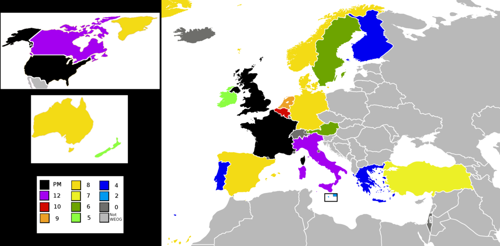
English: A map of the Western European and Others Group (WEOG), an unofficial group of the United Nations, with the number of years each member has served on the United Nations Security Council (UNSC), as of 2010. |
| Päiväys | (UTC) |
| Lähde | |
| Tekijä |
|
Lisenssi
Minä, tämän teoksen tekijänoikeuksien haltija, julkaisen täten tämän teoksen seuraavilla lisensseillä:
| Tämä tiedosto on lisensoitu Creative Commons Nimeä-JaaSamoin 3.0 Ei sovitettu -lisenssillä. | ||
| ||
| Lisensointimerkintä lisätiin tähän tiedostoon osana GFDL-lisensointipäivitystä. |

|
Voit kopioida, levittää ja/tai muuttaa tätä asiakirjaa GNU Free Documentation License -lisenssin version 1.2 tai minkä tahansa Free Software Foundationin julkaiseman myöhemmän version ehtojen alaisena; ei koske muuttumattomia kohtia, etukannen tekstejä eikä takakannen tekstejä. Kopio tästä lisenssistä on saatavilla osiossa GNU Free Documentation License. |
Voit valita haluamasi lisenssin.
Alkuperäinen tallennusloki
This image is a derivative work of the following images:
- File:BlankMap-Europe-v4.png licensed with Cc-by-sa-3.0-migrated, GFDL
- 2010-02-23T18:00:48Z Maps & Lucy 2100x1525 (131745 Bytes) Fixed the border of Kosovo with Serbia, proportioned British Overseas Cyprus Territories, San Marino, Vatican City, Monacco, and the Spanish Overseas Moroccan Territories, and added Guersney, Jersy, Liechtenstein, and Gibralt
- 2009-03-30T16:12:12Z Cradel 2100x1525 (131867 Bytes) Reverted to version as of 17:12, 8 March 2009
- 2009-03-20T22:20:11Z Avala 2100x1525 (70412 Bytes) what does this map represent? upload an alternative for unofficial views
- 2009-03-08T17:12:32Z Cradel 2100x1525 (131867 Bytes) Reverted to version as of 06:05, 5 April 2008
- 2008-11-20T01:00:56Z Tocino 2100x1525 (70412 Bytes) Reverted to version as of 19:36, 19 March 2008
- 2008-04-05T06:05:34Z Hoshie 2100x1525 (131867 Bytes) added the UK SBAs on Cyprus
- 2008-03-22T21:58:25Z Nightstallion 2100x1525 (131807 Bytes) Reverted to version as of 16:35, 13 March 2008
- 2008-03-19T19:36:48Z Patstuart 2100x1525 (70412 Bytes) Reverted to version as of 18:16, 11 March 2008 - see [[Image talk:BlankMap-World-v6.png#As stated in reversion]]
- 2008-03-13T16:35:26Z Nightstallion 2100x1525 (131807 Bytes) upload a variant if you wish, but the majority in Europe recognises or will recognise.
- 2008-03-11T18:16:50Z Avala 2100x1525 (70412 Bytes) there is no consensus in Europe
- 2008-02-24T02:42:03Z Hoshie 2100x1525 (131807 Bytes) Added Kosovo since it has been internationally recognized
- 2007-05-02T09:05:00Z Roke 2100x1525 (70412 Bytes) better version derived from svg
- 2006-06-26T06:32:12Z Roke 748x546 (27077 Bytes) minor - bottom left box
- 2006-06-26T05:53:48Z Roke 748x546 (27099 Bytes) {{Information |Description= blank map of europe, including north africa and western asia. With french overseas territories shown in inset lower left (French Guiana, Guadeloupe, Martinique, Reunion) |Source= derived from [[:Im
Uploaded with derivativeFX
Tiedoston historia
Päiväystä napsauttamalla näet, millainen tiedosto oli kyseisellä hetkellä.
| Päiväys | Pienoiskuva | Koko | Käyttäjä | Kommentti | |
|---|---|---|---|---|---|
| nykyinen | 11. heinäkuuta 2010 kello 16.17 | | 3 100 × 1 525 (241 KiB) | Mátyás | {{Information |Description=A map of the Western European and Others Group (WEOG), an unofficial group of the United Nations, with the number of years each member has served on the United Nations Security Council (UNSC), as of 2010. |Source=*[[:File:BlankM |
Tiedoston käyttö
Seuraava sivu käyttää tätä tiedostoa:
Tiedoston järjestelmänlaajuinen käyttö
Seuraavat muut wikit käyttävät tätä tiedostoa:
- Käyttö sivustolla ar.wiki.x.io
- Käyttö sivustolla en.wiki.x.io
- Käyttö sivustolla fr.wiki.x.io
- Käyttö sivustolla id.wiki.x.io
- Käyttö sivustolla tr.wiki.x.io
- Käyttö sivustolla www.wikidata.org